
Map-Based Geography MCQs of Assam
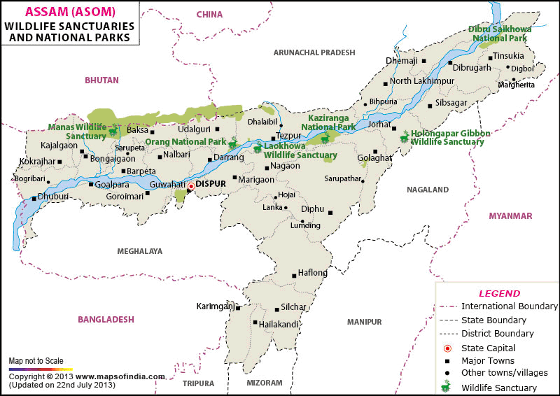
Assam General Knowledge – Module 2: Assam Geography MCQs
Topic: Map-Based Geography MCQs of Assam
I. Location & Boundaries (Map Orientation)
1. Assam is located in which part of India on the map?
A. North-Western India
B. North-Eastern India
C. Eastern Coastal India
D. Central India
Correct Answer: B
Explanation:
On the map of India, Assam is located in North-Eastern India, forming a key part of the Northeast region.
2. Which international boundary of Assam lies to the west?
A. China
B. Myanmar
C. Bhutan
D. Bangladesh
Correct Answer: D
Explanation:
On the western side of Assam, the international boundary is shared with Bangladesh.
3. Assam shares its northern international boundary mainly with:
A. Nepal
B. Bhutan
C. China
D. Myanmar
Correct Answer: B
Explanation:
The northern boundary of Assam touches Bhutan, clearly visible on political maps.
4. Which Indian state lies to the south of Assam on the map?
A. Arunachal Pradesh
B. Nagaland
C. Meghalaya
D. Manipur
Correct Answer: C
Explanation:
Meghalaya lies to the south of Assam, separated partly by the Shillong Plateau.
II. River System (Map-Based Identification)
5. Which major river flows across Assam from east to west?
A. Ganga
B. Barak
C. Brahmaputra
D. Teesta
Correct Answer: C
Explanation:
The Brahmaputra River flows east to west across Assam and dominates its physical map.
6. On the map, the Brahmaputra enters Assam near:
A. Guwahati
B. Tezpur
C. Dhubri
D. Sadiya
Correct Answer: D
Explanation:
The river enters Assam near Sadiya in the easternmost part of the state.
7. Which is the largest north-bank tributary of the Brahmaputra as seen on the map?
A. Manas
B. Subansiri
C. Kopili
D. Dhansiri
Correct Answer: B
Explanation:
The Subansiri River appears as the largest north-bank tributary on maps.
8. The Barak River flows through which valley shown on the map?
A. Brahmaputra Valley
B. Assam Valley
C. Barak Valley
D. Kapili Valley
Correct Answer: C
Explanation:
The Barak River flows through the Barak Valley in southern Assam.
III. Valleys & Plains
9. The Brahmaputra Valley is located in which part of Assam?
A. Southern Assam
B. Central Assam
C. Northern and central Assam
D. Western Assam only
Correct Answer: C
Explanation:
Maps show the Brahmaputra Valley stretching across northern and central Assam.
10. The Barak Valley is located in which direction from Guwahati?
A. North
B. South
C. East
D. West
Correct Answer: B
Explanation:
From Guwahati, the Barak Valley lies to the south, as seen on physical maps.
IV. Hills, Plateaus & Ranges
11. Which hill range separates the Brahmaputra Valley from the Barak Valley?
A. Patkai Range
B. Naga Hills
C. Barail Range
D. Garo Hills
Correct Answer: C
Explanation:
The Barail Range is clearly marked on maps separating the two valleys.
12. Karbi Anglong is located in which part of Assam?
A. Northern Assam
B. Western Assam
C. Central-southern Assam
D. Extreme eastern Assam
Correct Answer: C
Explanation:
Karbi Anglong lies in central-southern Assam, visible as a plateau region.
13. The Patkai Hills form Assam’s boundary with:
A. Bangladesh
B. Bhutan
C. Myanmar
D. China
Correct Answer: C
Explanation:
The Patkai Hills mark the eastern boundary with Myanmar on maps.
14. Which plateau lies immediately south of the Brahmaputra Valley?
A. Deccan Plateau
B. Shillong Plateau
C. Chota Nagpur Plateau
D. Tibetan Plateau
Correct Answer: B
Explanation:
The Shillong Plateau lies just south of the Brahmaputra Valley.
V. Districts & Urban Centres (Map-Based)
15. Which city is located on the southern bank of the Brahmaputra?
A. Tezpur
B. Dibrugarh
C. Guwahati
D. Dhubri
Correct Answer: C
Explanation:
Guwahati is located on the southern bank of the Brahmaputra.
16. Which city is located in the Barak Valley on the map?
A. Jorhat
B. Silchar
C. Tinsukia
D. Goalpara
Correct Answer: B
Explanation:
Silchar is the major urban centre of the Barak Valley.
17. Which district is located at the westernmost end of Assam?
A. Goalpara
B. Dhubri
C. Kokrajhar
D. Barpeta
Correct Answer: B
Explanation:
On the map, Dhubri appears as the westernmost district of Assam.
VI. National Parks & Protected Areas
18. Kaziranga National Park is located along which river?
A. Manas
B. Subansiri
C. Brahmaputra
D. Kopili
Correct Answer: C
Explanation:
Kaziranga National Park lies along the floodplains of the Brahmaputra.
19. Manas National Park is located near which international border?
A. India–Myanmar
B. India–China
C. India–Bangladesh
D. India–Bhutan
Correct Answer: D
Explanation:
Manas National Park is situated near the India–Bhutan border.
20. Orang National Park is located on which side of the Brahmaputra?
A. North bank
B. South bank
C. Middle channel
D. River island
Correct Answer: A
Explanation:
Maps show Orang National Park on the north bank of the Brahmaputra.
VII. Islands, Beels & Special Features
21. Majuli is located in which river?
A. Barak
B. Subansiri
C. Brahmaputra
D. Kopili
Correct Answer: C
Explanation:
Majuli is located within the Brahmaputra River.
22. Majuli is situated between which two rivers?
A. Brahmaputra and Manas
B. Brahmaputra and Subansiri
C. Barak and Surma
D. Kopili and Dhansiri
Correct Answer: B
Explanation:
Majuli lies between the Brahmaputra and Subansiri rivers.
VIII. Transport & Strategic Geography
23. National Waterway-2 follows which river in Assam?
A. Barak
B. Subansiri
C. Brahmaputra
D. Kopili
Correct Answer: C
Explanation:
The Brahmaputra River is designated as National Waterway-2.
24. The narrow corridor connecting Assam with the rest of India lies through:
A. Bhutan
B. Bangladesh
C. Siliguri Corridor
D. Patkai Hills
Correct Answer: C
Explanation:
The Siliguri Corridor connects Assam to mainland India, visible on India maps.
IX. Integrated Map Interpretation
25. Which physical feature protects Assam from cold northern winds?
A. Patkai Hills
B. Barail Range
C. Eastern Himalayas
D. Shillong Plateau
Correct Answer: C
Explanation:
The Eastern Himalayas, shown north of Assam, act as a climatic barrier.
26. The Brahmaputra Valley is widest in which part of Assam on the map?
A. Upper Assam
B. Central Assam
C. Lower Assam
D. Eastern Assam
Correct Answer: C
Explanation:
Maps show the valley widening significantly in Lower Assam.
27. Which river forms part of Assam’s drainage into Bangladesh?
A. Kopili
B. Subansiri
C. Barak
D. Jia Bharali
Correct Answer: C
Explanation:
The Barak River drains into Bangladesh and the Bay of Bengal.
28. Which hill district is located in southern Assam?
A. Karbi Anglong
B. Dima Hasao
C. Kokrajhar
D. Lakhimpur
Correct Answer: B
Explanation:
Dima Hasao (North Cachar Hills) lies in southern Assam.
29. Which direction does the Brahmaputra flow after entering Bangladesh?
A. East
B. West
C. South-West
D. North
Correct Answer: C
Explanation:
After entering Bangladesh, the Brahmaputra flows south-westward towards the Bay of Bengal.
30. Map-based geography of Assam mainly helps in understanding:
A. Historical events only
B. Political parties
C. Spatial distribution of physical and human features
D. Literary movements
Correct Answer: C
Explanation:
Map-based geography explains location, distribution, and inter-relation of rivers, hills, valleys, cities, and resources.
-
Assam map based geography MCQs
-
Assam geography map questions
-
Assam rivers hills map MCQs
-
Map based Assam GK questions
-
Assam geography MCQs for APSC
-
Assam physical map objective questions
-
Assam map questions for TET and Police
-
Assam geography MCQs with answers
🔹 Learn Assam Geography Effectively with Map-Based MCQs
These Map-Based Geography MCQs of Assam are prepared in strict alignment with the Assam-specific General Knowledge curriculum, making them highly relevant for competitive examinations and academic assessments. The questions focus on map reading, spatial orientation, rivers, hills, valleys, districts, national parks, and strategic locations of Assam, helping learners visualise geography rather than memorise isolated facts.
Highlight:
These Multiple Choice Questions (MCQs) are specially designed for APSC, UPSC, Assam Police, TET, Forest, Banking, Grade III & IV, and other competitive examinations. They are equally relevant for Assam school examinations, CBSE board exams, and college and university-level assessments across Assam, ensuring wide academic usefulness.
Regular practice of these map-based MCQs will significantly improve location accuracy, spatial understanding, and exam confidence, which are essential for scoring well in Assam Geography sections.
🔹 Frequently Asked Questions (FAQs)
Q1. What are Map-Based Geography MCQs of Assam?
Map-based Geography MCQs test location, direction, spatial distribution, and map interpretation skills related to Assam’s physical and human geography.
Q2. Are these map-based MCQs useful for APSC and Assam Police exams?
Yes. These MCQs are strictly aligned with the Assam-specific GK syllabus and are highly useful for APSC, Assam Police, TET, and other competitive exams.
Q3. Do these MCQs cover rivers, hills, districts, and national parks of Assam?
Yes. The questions include Brahmaputra and Barak rivers, hill ranges, valleys, districts, national parks, and international boundaries, all through map-based understanding.
Q4. Are these MCQs suitable for school and CBSE students?
Absolutely. These MCQs are equally relevant for Assam school exams, CBSE board exams, and college or university-level assessments.
Q5. How do map-based MCQs help in geography exam preparation?
They improve visual learning, spatial accuracy, and quick identification of locations, which are crucial for answering geography questions confidently in exams.