
Town Planning & Urban Architecture

Harappan Town Planning & Urban Architecture | History of India Notes
SECTION 2: Indus Valley Civilization (Harappan Civilization)
Timeline: c. 2500 BCE – c. 1750 BCE
(Ancient Indian History – Urban Civilization Phase)
Lesson: Town Planning & Urban Architecture
Introduction: Urban Genius of the Harappans
The Indus Valley Civilization (IVC) represents one of the earliest and most sophisticated urban civilizations of the ancient world. Flourishing roughly between 2500 BCE and 1750 BCE, it marks the Urban Civilization Phase in Indian history. One of the most striking and defining features of this civilization was its highly developed system of town planning and urban architecture, unmatched by most contemporary civilizations of the Bronze Age.
Unlike many early civilizations that evolved haphazardly, Harappan cities exhibit scientific planning, standardized construction, efficient drainage, and civic foresight. The uniformity visible across a vast geographical area indicates strong central planning and a shared architectural ideology. This lesson explores the chronological development, structural features, and historical significance of Harappan town planning in an examination-oriented manner.
Chronological Context of Harappan Urbanism
Early Harappan Phase (c. 3300–2600 BCE)
- Emergence of proto-urban settlements
- Use of mud bricks and limited planning
- Examples: Kot Diji, Amri
Mature Harappan Phase (c. 2600–1900 BCE)
- Peak of urban planning and architecture
- Planned cities with baked bricks
- Advanced drainage and civic structures
- Examples: Harappa, Mohenjo-daro, Dholavira, Kalibangan
Late Harappan Phase (c. 1900–1750 BCE)
- Decline of urban centers
- Disintegration of civic planning
- Shift towards rural settlements
Salient Features of Harappan Town Planning
1. Grid Pattern Layout
Harappan cities were laid out following a gridiron system, where:
- Streets ran north–south and east–west
- Roads intersected at right angles
- Cities were divided into rectangular blocks
This systematic planning reflects a deep understanding of geometry and civic organization, ensuring efficient movement, ventilation, and sanitation.
2. Division of the City: Citadel and Lower Town
Citadel
- Raised platform, often fortified
- Housed public and administrative buildings
- Symbol of authority and governance
Lower Town
- Residential area for common people
- Well-planned houses along straight streets
- Equal access to civic amenities
This division highlights functional zoning, a concept central to modern urban planning.
3. Standardized Brick Technology
One of the most remarkable aspects of Harappan architecture was the standardization of baked bricks:
- Brick ratio commonly 1:2:4
- Used uniformly across the civilization
- Strong, durable, and water-resistant
This uniformity suggests central regulation and skilled craftsmanship.
Residential Architecture
4. Planned Houses
- Mostly rectangular or square
- Built around central courtyards
- One or two storeys
- Few or no windows opening onto main streets (privacy)
5. Advanced Domestic Facilities
- Separate bathrooms
- Covered drains connected to main drainage system
- Soak pits for waste disposal
- Presence of private wells in many houses
This indicates a high level of domestic comfort and hygiene consciousness.
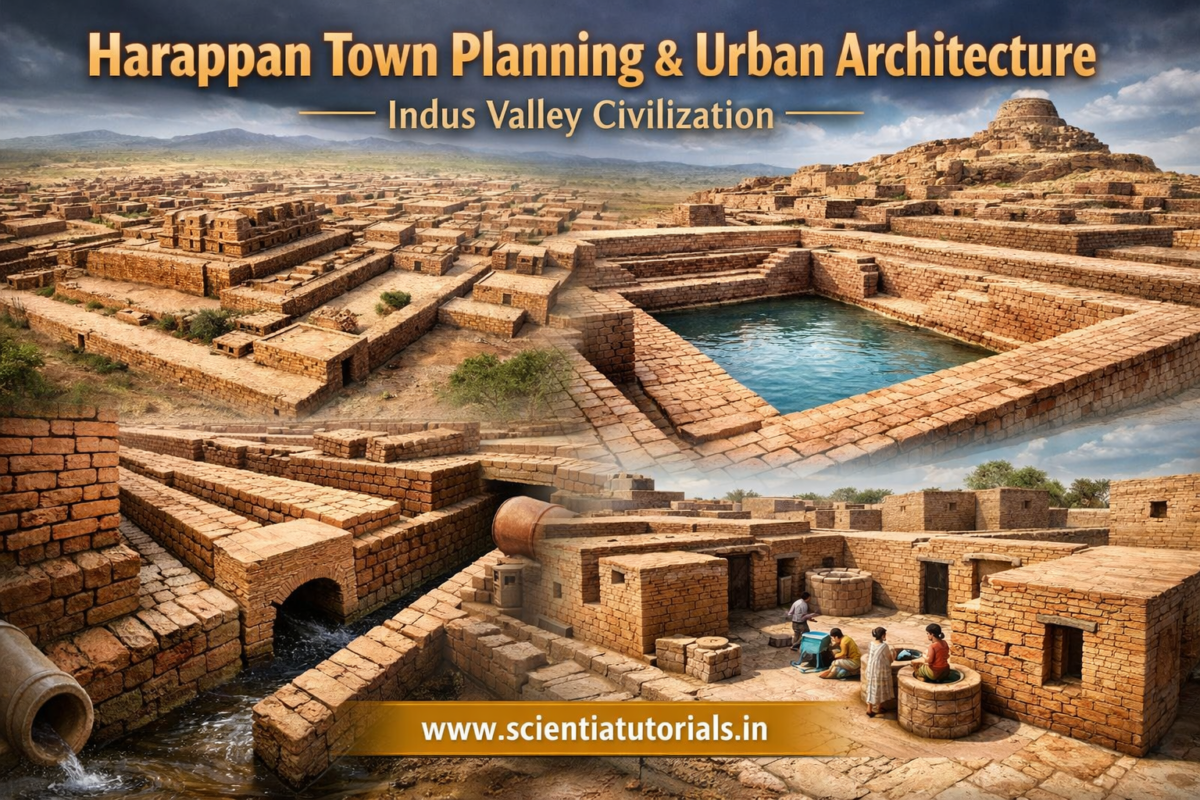
6. Drainage System: Hallmark of Harappan Urbanism
The drainage system of the Indus Valley Civilization is considered the most advanced of the ancient world.
Key Features
- Covered drains made of baked bricks
- Drains laid along main streets
- Inspection chambers at regular intervals
- Gradient maintained for smooth flow
No other contemporary civilization, including Mesopotamia or Egypt, matched this level of urban sanitation.
Public Architecture and Civic Structures
7. The Great Bath
Located at Mohenjo-daro, the Great Bath is:
- A large rectangular water tank
- Waterproofed with bitumen
- Surrounded by rooms and corridors
Significance:
- Likely used for ritual bathing
- Indicates importance of purity and collective rituals
8. Granaries
- Found at Harappa and Mohenjo-daro
- Massive brick structures with ventilation
- Located near river or citadel area
Purpose:
- Storage of surplus grains
- Evidence of organized economy and state control
9. Assembly Halls and Dockyards
- Large pillared halls suggest administrative or community gatherings
- Dockyard at Lothal indicates:
- Maritime trade
- Planned hydraulic engineering
Water Management System
10. Wells and Reservoirs
- Numerous wells in almost every city
- Built with circular baked bricks
- Dholavira had:
- Sophisticated reservoirs and channels
- Rainwater harvesting system
This reflects environmental adaptation and sustainability.
Urban Planning at Major Harappan Sites
Mohenjo-daro
- Best example of drainage and sanitation
- Great Bath and granaries
- Wide streets and uniform housing
Harappa
- Strong fortifications
- Granaries and working platforms
- Evidence of administrative control
Dholavira
- Three-fold division: Citadel, Middle Town, Lower Town
- Massive water reservoirs
- Unique stone architecture
Kalibangan
- Fire altars
- Evidence of town planning in early phase
- Ploughed field remains nearby
Town Planning and Social Organization
Harappan town planning reflects:
- Absence of palaces or grand temples
- No clear evidence of extreme social inequality
- Uniform housing standards
This suggests a society based on collective civic discipline rather than autocratic rule.
Comparative Perspective
| Civilization | Urban Planning | Drainage |
|---|---|---|
| Indus Valley | Highly planned, grid system | Excellent |
| Mesopotamia | Semi-planned | Limited |
| Egypt | Monument-focused | Minimal |
| China (Shang) | Fortified towns | Moderate |
The Indus Valley Civilization clearly stands out for its people-centric urban planning.
Decline of Urban Planning
By c. 1900 BCE, Harappan urban features declined:
- Breakdown of drainage systems
- Abandonment of cities
- Reduced brick quality
Probable Causes:
- Environmental changes
- River shifts
- Decline in trade
- Internal socio-economic stresses
Historical Significance of Harappan Town Planning
- Earliest example of scientific urban planning in India
- Foundation for later urban traditions
- Demonstrates advanced knowledge of:
- Engineering
- Hygiene
- Architecture
- Governance
Examination-Oriented Key Points
- Grid pattern and standardized bricks = hallmarks
- Drainage system = most advanced feature
- No palaces or temples = unique social structure
- Citadel–Lower Town division = functional zoning
- Town planning strongest during Mature Harappan Phase
Conclusion
The town planning and urban architecture of the Indus Valley Civilization reflect a level of civic maturity and technical expertise that was far ahead of its time. The Harappans built cities not merely for survival, but for order, hygiene, comfort, and sustainability. Their achievements continue to inspire modern urban planners and remain a cornerstone topic in the study of Ancient Indian History.
Below is a well-structured, examination-oriented set of 25 Questions with clear and accurate Answers based strictly on the lesson “Town Planning & Urban Architecture” under Section 2: Indus Valley Civilization (Harappan Civilization).
The questions progress from basic concepts to analytical and comparative levels, making them suitable for UPSC, State PSC, SSC, and university examinations.
Indus Valley Civilization – Town Planning & Urban Architecture
Questions with Answers (25 Q&A Set)
1. What is meant by town planning in the context of the Indus Valley Civilization?
Answer:
Town planning in the Indus Valley Civilization refers to the systematic and scientific layout of cities, including grid-pattern streets, standardized bricks, efficient drainage systems, zoning of areas, and well-designed residential and public structures.
2. During which phase did Harappan town planning reach its peak?
Answer:
Harappan town planning reached its peak during the Mature Harappan Phase (c. 2600–1900 BCE).
3. What was the basic layout pattern followed in Harappan cities?
Answer:
Harappan cities followed a gridiron pattern, with streets running north–south and east–west intersecting at right angles.
4. Name two major Harappan cities known for advanced town planning.
Answer:
Mohenjo-daro and Harappa are two major cities renowned for advanced town planning.
5. How were Harappan cities generally divided?
Answer:
Harappan cities were generally divided into two main parts:
- Citadel – elevated and fortified area
- Lower Town – residential area for the common people
6. What was the purpose of the Citadel?
Answer:
The Citadel housed important public buildings such as granaries, assembly halls, and ritual structures, and likely served administrative and ceremonial functions.
7. Describe the main features of the Lower Town.
Answer:
The Lower Town consisted of well-planned residential houses, straight streets, drainage facilities, and access to wells, indicating organized urban living for the general population.
8. What type of bricks were used in Harappan construction?
Answer:
Harappans used standardized baked bricks, typically in the ratio of 1:2:4, ensuring strength and uniformity across settlements.
9. Why is the Harappan drainage system considered exceptional?
Answer:
It was fully covered, well-aligned with streets, connected to household drains, equipped with inspection chambers, and maintained proper gradients—making it the most advanced drainage system of the ancient world.
10. How were houses designed in Harappan cities?
Answer:
Houses were usually built around central courtyards, had one or two storeys, minimal street-facing windows, and separate bathing areas.
11. What evidence suggests a strong emphasis on hygiene among the Harappans?
Answer:
The presence of bathrooms in houses, covered drains, soak pits, wells, and systematic waste disposal highlights their concern for hygiene and sanitation.
12. What was the Great Bath, and where was it located?
Answer:
The Great Bath was a large rectangular water tank used for ritual bathing, located at Mohenjo-daro, and waterproofed with bitumen.
13. What do granaries indicate about Harappan society?
Answer:
Granaries indicate surplus agricultural production, organized storage, state control, and an advanced economic system.
14. Which Harappan site is famous for its dockyard, and what does it signify?
Answer:
Lothal is famous for its dockyard, signifying maritime trade, shipbuilding knowledge, and advanced hydraulic engineering.
15. How was water supply managed in Harappan cities?
Answer:
Water supply was managed through numerous wells, reservoirs, rainwater harvesting systems, and channels, ensuring regular access to clean water.
16. Which site demonstrates the most advanced water management system?
Answer:
Dholavira demonstrates the most advanced water management system with large reservoirs and carefully planned channels.
17. What role did standardized measurements play in town planning?
Answer:
Standardized measurements ensured uniform construction, efficient planning, and consistency across cities, reflecting centralized control and technical expertise.
18. Were temples or palaces found in Harappan cities? What does this imply?
Answer:
No clear evidence of palaces or temples has been found, suggesting a society focused on civic organization rather than ruler-centric or theocratic power.
19. How does Harappan town planning differ from Mesopotamian cities?
Answer:
Harappan cities were more systematically planned with superior drainage systems, whereas Mesopotamian cities were semi-planned with limited sanitation.
20. What does uniform housing suggest about Harappan social structure?
Answer:
Uniform housing suggests limited social inequality and an emphasis on collective civic life rather than extreme class divisions.
21. What materials were commonly used in Harappan architecture?
Answer:
Baked bricks, mud bricks, stone (especially at Dholavira), and timber for roofing were commonly used.
22. How did Harappan town planning contribute to urban sustainability?
Answer:
Efficient drainage, water conservation, durable construction materials, and environmental adaptation contributed to long-term urban sustainability.
23. What changes are visible in town planning during the Late Harappan Phase?
Answer:
Decline in drainage maintenance, irregular layouts, poorer brick quality, and abandonment of major cities are visible during the Late Harappan Phase.
24. Mention two causes for the decline of Harappan urban planning.
Answer:
Environmental changes such as river shifts and floods, along with decline in trade and economic disruption, contributed to the decline.
25. Why is Harappan town planning considered a landmark in Indian history?
Answer:
It represents the earliest and most advanced example of scientific urban planning in India, laying the foundation for later urban traditions.
Below is a well-structured, examination-oriented set of 25 MCQs with correct answers and detailed concept-clearing explanations based strictly on the lesson “Town Planning & Urban Architecture” under Section 2: Indus Valley Civilization (Harappan Civilization).
The questions are framed to match the level of UPSC Prelims, State PSC, SSC, and university examinations, moving from factual clarity to analytical understanding.
Indus Valley Civilization – Town Planning & Urban Architecture
MCQs with Answers & Explanations (25 Questions)
1. The grid pattern of Harappan cities implies which of the following?
A. Religious symbolism
B. Organic growth of settlements
C. Scientific urban planning
D. Military considerations
Correct Answer: C
Explanation:
The grid pattern, with streets intersecting at right angles, reflects deliberate and scientific planning rather than organic or unplanned growth. It indicates knowledge of geometry, measurement, and civic administration.
2. Harappan town planning reached its highest development during the:
A. Early Harappan Phase
B. Mature Harappan Phase
C. Late Harappan Phase
D. Post-Harappan Phase
Correct Answer: B
Explanation:
The Mature Harappan Phase (c. 2600–1900 BCE) witnessed fully developed cities with baked bricks, drainage systems, standardized layouts, and large public structures.
3. Which of the following was a distinctive feature of Harappan streets?
A. Circular roads
B. Narrow and irregular lanes
C. Straight roads crossing at right angles
D. Radial pattern from a central point
Correct Answer: C
Explanation:
Harappan streets followed a rectilinear grid pattern, demonstrating advanced town planning uncommon in contemporary civilizations.
4. Harappan cities were generally divided into which two major parts?
A. Inner city and outer city
B. Administrative zone and market zone
C. Citadel and Lower Town
D. Religious quarter and residential quarter
Correct Answer: C
Explanation:
The Citadel housed public and administrative buildings, while the Lower Town consisted of residential areas for the common people.
5. The Citadel in Harappan cities was usually:
A. Located at the city center
B. Built at a lower elevation
C. Raised on a high platform
D. Used exclusively for housing
Correct Answer: C
Explanation:
The Citadel was elevated, possibly to protect important structures from floods and to symbolize authority.
6. Which brick ratio was most commonly used in Harappan construction?
A. 1:1:2
B. 2:3:5
C. 1:2:4
D. 3:4:6
Correct Answer: C
Explanation:
The standardized brick ratio of 1:2:4 is a hallmark of Harappan architecture and reflects centralized planning and technical uniformity.
7. What material was primarily used for constructing drains in Harappan cities?
A. Mud bricks
B. Stone slabs
C. Wooden planks
D. Baked bricks
Correct Answer: D
Explanation:
Drains were constructed using baked bricks, making them durable and resistant to water damage.
8. Why is the Harappan drainage system considered unique among ancient civilizations?
A. It was decorative
B. It was underground and systematic
C. It was connected only to public baths
D. It was limited to elite areas
Correct Answer: B
Explanation:
The Harappan drainage system was covered, connected to individual houses, laid along streets, and provided with inspection chambers—far superior to contemporary systems.
9. Most Harappan houses were built around:
A. Open streets
B. Public halls
C. Central courtyards
D. Riverbanks
Correct Answer: C
Explanation:
Central courtyards provided light, ventilation, and privacy, showing concern for comfort and domestic planning.
10. Which feature best reflects the Harappans’ concern for privacy?
A. High walls around cities
B. Absence of windows facing main streets
C. Underground houses
D. Use of curtains
Correct Answer: B
Explanation:
Most houses did not open directly onto main roads, indicating a clear understanding of private and public spaces.
11. The Great Bath is associated with which Harappan site?
A. Harappa
B. Kalibangan
C. Lothal
D. Mohenjo-daro
Correct Answer: D
Explanation:
The Great Bath at Mohenjo-daro is one of the most remarkable public structures, possibly used for ritual bathing.
12. The waterproofing of the Great Bath was achieved using:
A. Lime plaster
B. Gypsum
C. Bitumen
D. Clay mortar
Correct Answer: C
Explanation:
Bitumen was used to make the structure watertight, highlighting advanced construction techniques.
13. Granaries in Harappan cities primarily indicate:
A. Military storage
B. Religious offerings
C. Surplus agricultural production
D. Trade taxation
Correct Answer: C
Explanation:
Large granaries point to surplus production, systematic storage, and organized economic management.
14. Which Harappan site is famous for its dockyard?
A. Banawali
B. Rakhigarhi
C. Dholavira
D. Lothal
Correct Answer: D
Explanation:
The dockyard at Lothal suggests overseas trade and advanced hydraulic engineering.
15. The presence of numerous wells in Harappan cities suggests:
A. Scarcity of water
B. Centralized water control only
C. Efficient water supply system
D. Ritual importance of water only
Correct Answer: C
Explanation:
Multiple wells ensured easy access to clean water for domestic and civic use.
16. Which Harappan site shows the most advanced water-management system?
A. Dholavira
B. Harappa
C. Chanhudaro
D. Kalibangan
Correct Answer: A
Explanation:
Dholavira had massive reservoirs, channels, and rainwater harvesting systems adapted to an arid environment.
17. The absence of palaces and large temples in Harappan cities suggests:
A. Weak religious beliefs
B. Foreign rule
C. Egalitarian social structure
D. Nomadic lifestyle
Correct Answer: C
Explanation:
Uniform housing and absence of monumental royal or religious structures suggest limited social hierarchy.
18. Which feature distinguishes Harappan town planning from Mesopotamian cities?
A. Use of bricks
B. Presence of markets
C. Superior drainage system
D. Religious buildings
Correct Answer: C
Explanation:
Harappan drainage systems were far more advanced and systematic than those of Mesopotamia.
19. Harappan houses generally had:
A. No bathrooms
B. Common public toilets
C. Attached bathing areas
D. Open sewage disposal
Correct Answer: C
Explanation:
Most houses had private bathing areas connected to covered drains, reflecting hygiene awareness.
20. Which of the following reflects centralized control in Harappan cities?
A. Irregular streets
B. Standardized bricks and measurements
C. Regional architectural styles
D. Decorative walls
Correct Answer: B
Explanation:
Uniform brick sizes and layouts across vast regions indicate centralized planning or shared administrative norms.
21. What change is observed in town planning during the Late Harappan Phase?
A. Improved drainage
B. Larger cities
C. Decline in civic planning
D. Increase in monumental architecture
Correct Answer: C
Explanation:
Late Harappan sites show poor maintenance of drains, irregular layouts, and reduced urban features.
22. The Lower Town mainly served which purpose?
A. Religious ceremonies
B. Administration
C. Residential occupation
D. Military defense
Correct Answer: C
Explanation:
The Lower Town was primarily residential, housing the majority of the population.
23. Which material was prominently used at Dholavira instead of bricks?
A. Mud
B. Timber
C. Stone
D. Lime
Correct Answer: C
Explanation:
Dholavira is unique for its extensive use of stone, unlike other brick-based Harappan cities.
24. Harappan town planning can best be described as:
A. Ruler-centric
B. Temple-centric
C. Trade-centric
D. People-centric
Correct Answer: D
Explanation:
Focus on sanitation, housing, water supply, and uniformity reflects concern for collective civic life.
25. Why is Harappan urban planning considered a landmark in Indian history?
A. It introduced iron tools
B. It represents the earliest scientific urban planning
C. It focused on monument building
D. It promoted imperial expansion
Correct Answer: B
Explanation:
Harappan cities provide the earliest evidence of systematic, scientific, and sustainable urban planning in India.
Targeting Exams Section
This content is highly useful for the following examinations:
-
UPSC Civil Services Examination (Prelims & Mains – History of India)
-
State Public Service Commissions (PSC)
-
SSC (CGL, CHSL – Ancient History)
-
University Semester Exams (Ancient Indian History)
-
Teaching Eligibility Tests (TET/NET – History)
Related / Supporting Keyphrases
-
Indus Valley Civilization town planning
-
Harappan urban architecture features
-
Grid pattern cities of Harappans
-
Drainage system of Indus Valley Civilization
-
Great Bath of Mohenjo-daro
-
Citadel and Lower Town Harappan cities
-
Harappan civilization UPSC notes
-
Ancient Indian urban planning
-
Mature Harappan Phase architecture